Friday 4 September 2015

Goodbye Baby, Aman


EPILOGUE

It was an amazing trip.   

Southern route Westward, Northern route Eastward


Every day presented itself in different and fascinating ways.  I saw what the American’s would call “the heart of America”, and met many of their salts-of-the-earth.  Some more salty than other. 

As I mentioned at the beginning of this blog I wanted to meet and interact with the real soles who inhabit the land, not just “the haves” in their SUV’s”.  Those I met had stories to tell that were as diverse and fascinating as the land itself.  
Where have all the people gone?
Would I go back and do the trip again.  Yes, but more focused the next time around.

There are places I’d skip to concentrate more on other places.  The further west I pushed the more the land seemed to call out and enticed me to get off the beaten track and explore.  
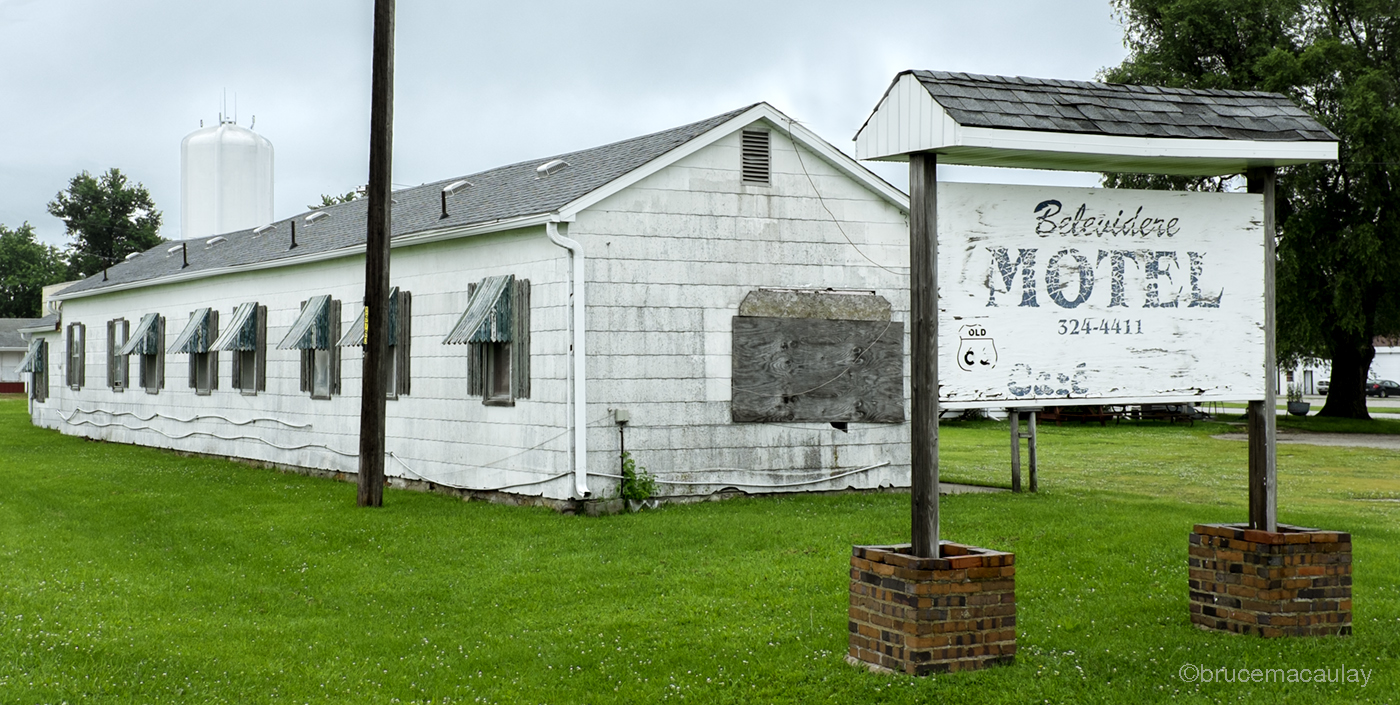
Once a busy place, now no one drops by
I realize that this might sound trite but not until I got off of the beaten track, sometimes way off, to the point I hoped I hadn’t made a wrong decision, did I really find I was exploring what R66 had once really been like and how much it made and then broke the towns and communities it touched.  Many of the locations I ventured into there wasn't any cell coverage so if anything had gone wrong,  well,  I'll let your imagination fill in the rest. 

Once the great Route 66
Even the vehicle has rusted away
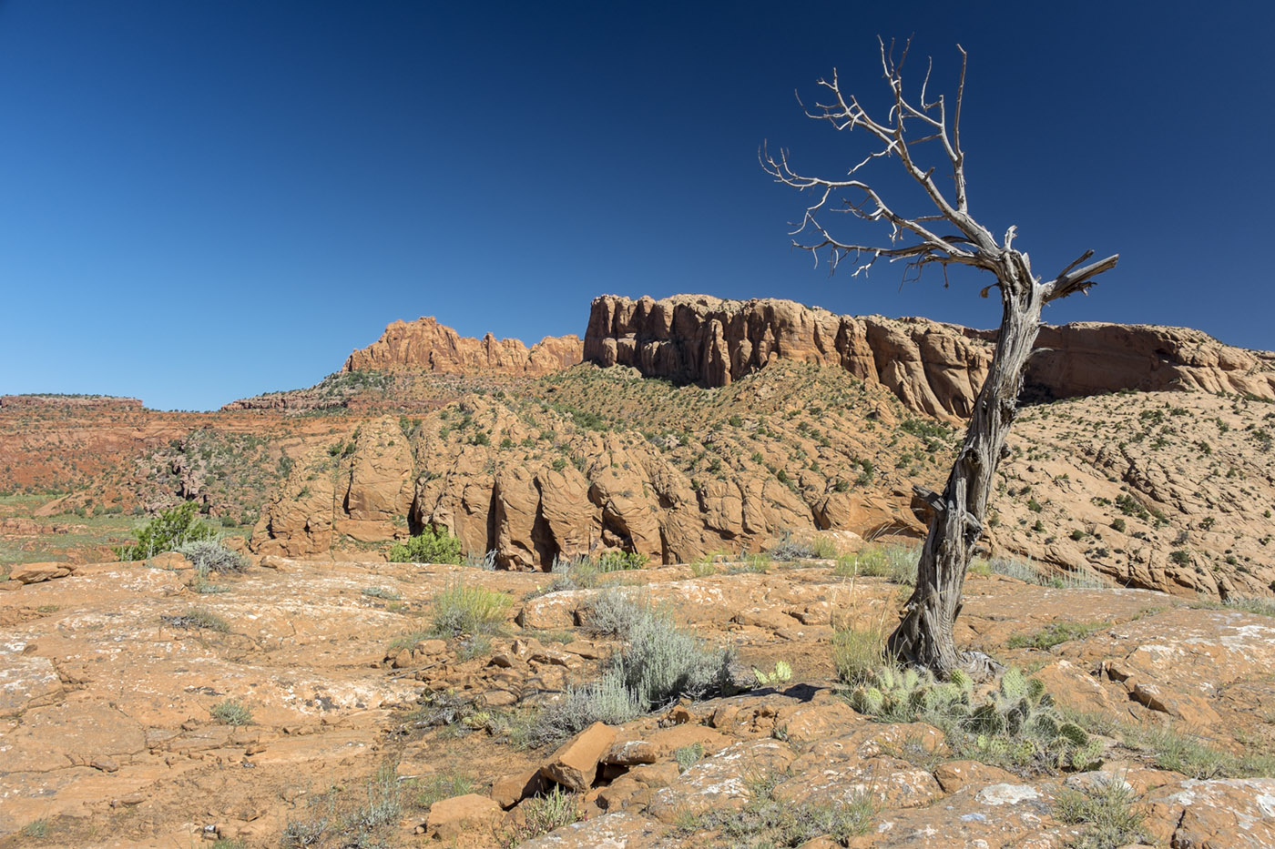
A house of stone
Maybe it’s simply that the huge tracks of open land, further west, were easier to photograph than the urban centres teeming with people, industry and vehicles.  Or maybe those vast empty parcels of land, that the west provided, gave you the aura of time standing still where nothing seems to have changed except the grass on the front lawns was much longer.

Perhaps the lawn mower is broken
If I were to make such a trip again what would I do differently? Two things.

First 
Equipment, I’d add two items. 
A: a Tilly Hat, baseball caps are just a pain, I took mine off so often that I ended up giving myself a real sunburn on the top of my head (primary cause; lack of hair) within two days. 
B: a GPS unit for my DSLR. Try as I did, it was just too time-consuming and sometimes impossible to know where I actually was.  Remember I chose to stay off the beaten track and many places I visited either didn’t have a visible name or I couldn’t find one. Case in point was Jericho in Arizona.  It did appear on the map but not the GPS.  The one showing up on the GPS was 26 miles away from the one I was looking for.  I was only able to find the remains of the hamlet when I happened to find a weather-beaten and faded sign laying on the ground, that said Jericho Cemetery.

Second
Planning   
I’d do a bit more reading about the areas I’m going to visit.  Though I knew a great deal about the history of Route 66, I knew very little about many of the small towns and areas I visited. Now, the object of my trip was to visit and explore as much as possible and to this end, I feel I partially met my objectives. I say partially because once in an area I quickly came to realize that there was much more to explore than I had thought there would be. Next time I’d narrow my scope and put more concentration on fewer places. 
Round Barn
Places I loved and those I couldn’t wait to leave. Those places I'll leave for you to discover, my preferences, likes and dislikes,  might not be yours.

Funny, but sometimes it’s the small things you recall most vividly about such a trip.  One place in particular that has stuck in my memory was in the town of Carthage, Missouri.  I hunted out the old civil war battlefield where the first major battle of the war took place and was struck by the serenity of the place.  For such a bloody part of the US history, 650,000 killed, this cool grassy park set under the shade of tall trees seemed such a contrast to the reality of the horror that once took place there.  It was surreal standing there in the soft drizzle with the only sound being heard was that of a soft breeze, gently rustling the leaves.  
How could such a lovely place have once been a killing field

Some of Route 66's so-called ghost towns really aren’t.  They might have been headed in that direction but the communities revitalized and restored their past to beckon today’s tourist to stop and spend some time and dollars experiencing what once was.  These places, with some items of interest to photograph, were just too Disney in design for my liking.   They are magnets for the passing tourist, typical souvenir shops, (most everything was made in China) and fancy restaurants pushing “Route 66 hamburgers” and cheap beer.  The Winnebago’s and fancy SUV’s would be parked out front and Ma, Pa and all the young'ns would be stuffing their faces with Nachos drenched in melted processed cheese.
Garish, but the tourists seem to love it
Crowds just aren’t my thing but sometimes they can’t be avoided, unless…

Popular sights such as Horseshoe Bend and Monument Valley are lures for the selfie shooters and one just can’t avoid the busloads of tourists.  However, the majority vanish the moment the sun slips behind the horizon or the weather turns nasty.   In the twilight the desert takes on a completely different look, the red soil turns pink and bushes appear to glow.
As the sun goes down, the colours come out.
Leaving Monument Valley isn’t the end of the magnificent sights but the beginning. As I headed north towards Moab I kept one eye glued to my rear view mirror and glad I did.  The amazing thing about this part of the country is that the beauty surrounds you 360º and even if you don’t capture it on a sensor, you do so in your mind's eye. 

As I headed into the Colorado Rockies I experienced the lack of something that most of us just take for granted.  Oxygen.  As I climbed higher and higher I realized that I needed to apply more gas to the throttle and it suddenly dawned on me that the traffic, in general, was starting to slow down.  I became aware that the huge trucks engines were growling as if they were about to endure heart attacks, then the penny dropped.  Oxygen or the lack thereof. At 11,000 plus feet, my engine was showing signs of becoming oxygen deprived.  Considering that small aircraft are not allowed to fly above 10,000 feet without oxygen, here I was at over 11,100 feet.

Descending over 11,000 feet on nearly a 6% grade presents its own set of problems. Using your brakes all the way down can and did in some cases result in you reaching the bottom minus your brakes.   Not me, I used my gears and just touched the brakes when needed but some of those big heavy SUVs weren't quite so wise. I passed a few who were pulled over with either very little or no brakes left.

Nebraska proved to be as expected, wide-open, flat, cattle and farming country.  Iowa was an entirely different matter. 

I had planned on driving straight through Nebraska and Iowa. However, Iowa's lush green rolling hills with miles of unpaved country roads are a photographer's dream come true and I found myself being lured off of I-70 to spend time capturing the wonderful sights.   

Iowa's green fields and dusty roads
Just around Gary, Indiana, I stopped for my last night on the road.  The next day I crossed over, again at Sarnia, and straight on to Markham.

Many have asked questions asked about my trip, here are a few of my answers:
Days on the road: 15
Principal lodging: Motel 6
Best available Wi-Fi connection: McDonalds
Best coffee: McDonalds
• Bottles of water consumed: 60+
Miles/Kilometers traveled: 6,275/10,100
Gallons/Litres of gas purchased: 160/605
Lowest gas prices: Michigan
Highest gas prices: California
Least photos taken: Nebraska
Most photos taken: New Mexico/Arizona
Highest altitude: 11,116 ft, Colorado
Hottest temperature: 117ºF/47.2C
Principal cameras: Nikon D610 and Fuji X100s
Frames Shot: 8500
Average distance travelled per day: Too Many
Best photographic opportunities: Missouri, Kansas, Oklahoma, New Mexico, Arizona, and Iowa

Would I do a similar trip again, Yes.  There are just too many things to see all, in one go, and many more way-off the beaten track places to explore.

-30-

Friday 31 July 2015

Nothing like the smell of burnt rubber first thing in the morning.


The end is near.  Or is it..

I am writing this just miles from the Canadian border, eating my last gourmet road breakfast, guess where? 

Yesterday I didn’t post simply because I was just too darn tired. Did a 16 hour day and 656 miles, that's 1056 Kilometers.
 
I had expected that once I left Monument Valley things would be pretty mundane for the rest of the trip back.   

WRONG…

To start, as I was heading north to Moab I did as I often did and kept one eye on my rear view mirror to see what might be materializing behind me. The beauty and scope of the country is just too powerful to speed by without “stopping to smell the roses” or in this case cactus flowers. Just don’t sick your nose too close.
Though it's a desert it is teaming with life

Pushing upward these ancient beauties are real desert jewels.

Came across a group, no gaggle is a better word, of girls on a GAP trip.  When I say came across it’s more like nearly ran over. 

Ok, now before any of you get your nickers-in-a-knot about running down the local wildlife, please, let me explain.

Going north from Monument Valley to Moab on Hwy 163 the road runs as straight as an arrow for about 4 miles, increasing in elevation until it reach a small plateau.    
Where else does a ribbon of asphalt add to the scene
At the plateau, there is a pullover and this is where 20 giggling and very excited young ladies were gathered to have their pictures taken with the majestic view in the BG.  They were turning the photo moment into a full-fledged production.  Taking their pictures in groups, jumping as a group, running towards the camera as a group and any other combinations you can imagine. 

The thing is this, for an approaching car (that being me) anyone or things on the plateau aren't visible until just before you crest.    Doing 70+ mph the gaggle suddenly came into view and I stepped on my brakes and the girls scattered, like a flock of crows feasting on road kill.  

The 18 wheeler only meters off of my bumper, (he was pouring on the diesel to make the grade) hauling 50,000 pounds (that's 22,679 kilos) of rebar, said it best.  With his air horn piercing the quite still landscape and dense blue smoke pouring from his tires the road becoming shrouded in a blue haze.  I'm sure the girls felt their GAP trip was just about to be terminated.  

The only damage was about $1,000.00 worth of rubber being left on the very hot pavement and a very annoyed "long haulier".

Wisely, the girls moved further down the road so they could better see oncoming traffic.  I pulled over to watched their antics, the trucker needed what little momentum he had left to finish the climb and couldn't stop.  Great fun, unless you're the trucker.
 
The excitement

Oh to be young and carefree again.
I've said it before but it's worth repeating.  This part of the country, for all of its raw and hostile environment, is indescribably beautiful.

For all of its beauty, you have to be careful as the desert can jump up and bite you just when you least expected it.
 
Caution is needed or you too could get bitten.
Arrived in Moab and hunted for Hwy 128.  Why 128?  Well, remember Don Robertson at the Ghost Mining town in Jerome?  Well, he told me to find this road "you'll be glad you did".

Hwy 128 runs beside the Colorado River in a gorge with the steep red sandstone walls towering above you.  Though taking 128 adds about an hour to your day, it’s well worth it.  The traffic moves at a snail's pace, everyone is soaking up the beauty. 

Glad I took Don's advise instead of staying on Hwy 163 and pounding straight for I-70.
 
Surprised that anything crows in this heat

These things  come crashing down on a regular basis and the road signs warn you.
Colorado winding along Hwy 128 near Moab

Dead Black Trees against the backdrop of a Crystal Blue sky and Red Butte.
About to go rafting on the mighty C

I had expected that getting to Denver would be pretty straightforward.  Like everything else about this trip, Wrong Again!

The highway is a series of huge climbs, through tunnels, past rivers, up and down valleys, though lovely sleepy ski resort towns just waiting to be awakened by the arrival of snow.  You become very aware that your car’s engine is labouring to suck oxygen in the thin air of 11,125 plus feet and your ears need to be constantly purged. Man, does you gas consumption shoot up.  Despite being on a high-speed interstate the trip is not quick.  Take a wrong exit and it’s 20 minutes before you can correct your mistake.  Great fun.

Not much oxygen at this altitude. Even though the speed limit is posted as 60 you can see my speed is just 45.

Check out the altitude on my GPS's altimeter. Even the GPS has desert dust on it.
About to enter the 1.7 mile (2.74 km) Johnson Tunnel
Inside the tunnel

After Colorado, you enter the flat open expanse of Nebraska.  Talk about from the sublime to the ridiculous.  Actually, there isn't anything ridiculous about Nebraska but the sudden change in landscape when you pop out of the tunnel is extreme.  

Onward, onward you charge, thank goodness the highway speed is set at 75 mph which means most are doing 80+.

Then before you know it you hit Iowa.  Gorgeous slow rolling luscious green fields dotted with miles of wind turbines. I found an exit and just had to pull off of I-80 to stop to soak up the beauty and do some photography.   
Rolling Green Hills of Iowa
Truck on dusty Iowa country road

Iowans take their conservation seriously. Over 27% of Iowa's energy needs come from wind.   Not all solar need to boring in design. 

Wind Turbines in Iowa
I shot this pic as it struck me as funny.  It's a single blade from a wind turbine.  At 127 feet tall and 36 tons, you don't want this thing to topple over.  A full unit weights 171 tons.  

Single Turbine Blade as a monument at a weigh scale stop

What struck me as funny was that it reminded me of a scene in the original 1968 Planet of the Apes, with Charleston Heston.  In the scene, Heston who is an astronaut who time travels into the future and witnesses apes paying homage to what they think is an image of their god.  In fact, it's an ICBM missile.
ICBM in scene from 1968 Planet of the Apes
While the wind turbine's blade is used for peaceful purposes the ICBM is just the opposite. I was struck by the similarities even though how opposite these two objects are and what they stand for.  

Funny how your mind goes when alone for long periods of time. The strangest things pop into one's head.


More to come….


Wednesday 29 July 2015

Into Tse Bii' Ndzisgaii


Monument Valley

If you stand long enough, squint and gaze into the far distance you just might see a dust plume and a galloping team of four horses pulling a stagecoach, along the base of a butte.  Following the coach you might also see a troop of US Calvary led by a distinct figure wearing a yellow bandanna and a white trooper’s hat with the front brim turned up.  That imposing silhouette looks very familiar, I'm darn sure I've seen that feller somewhere before.  Could it be?  I think it is! Yes, it’s..

Please, permit me this bit of fantasy.  I grew up with the likes of John Ford’s classic  Stagecoach”, “Fort Apache” and more. It was these stunning black & white vista panoramic movies that featured the towering sandstone buttes of Monument Valley in Arizona. The Navajo call them Tse Bii’ Ndzisgaii meaning valley of the rocks.  Ford shot many of his western movies here and was an ardent champion of this unique area of the US.  In fact, Monument Valley has been catapulted into the American consciousness thanks to the many westerns that Ford shot here.

 
On the way to Monument Valley
Arriving at Monument Valley you can either stay on the rim and view the buttes from the comfort of the Navajo welcome centre or, as I did, you can test yourself and your cars endurance abilities and venture onto the valley floor, to drive "the loop".   

Driving "the loop" is not for the faint of heart. 

The first 100 yards consists of a 45º slope in the very soft red soil.  SUV’s can find it a challenge so you can only imagine how the average car does.  Not to go unmentioned are the washboard road surfaces in many spots that can seriously rattle and shake both you and your car.  There is a dentist at the welcome centre to replace fillings that get jarred loose and a Navajo towing service to the nearest garage to fix your car's suspension ;-)

Nothing can prepare you for the dust you are about to experience.  Every vehicle emerged from the one and a half hour trip covered in a thick layer of Arizona red dust.  The visitors who opted not to take their own vehicle into "the loop" but instead choose the open air vehicle guided tours needed to wear dust masks.  All the time you are in the Monument Valley area there is dust everywhere. It creeps into your eyes, nose, ears, hair and worst of all your camera's sensor.  Some say don't change your lens while on the valley floor but one lens can't deliver all your needs in such a place that's screaming to be captured with everything from a fish-eye to a telephoto.
 
Did I mention the dust?
It’s definitely worth putting up will all the dust.  Monument Valley is breathtaking and cannot be truly appreciated until it's viewed from "the loop".  The buttes tower above you on your right, you’re left, in front and behind you. At every turn people were popping in and out of their vehicles with cameras, cell phones, tablets snapping, snapping, snapping.  Some try to capture the beauty, others check their emails, while others shoot who-knows-what.

Typical family scene. At least this group left their vehicle, many don't.
Cars on "the loop"
The point from which John Ford shot many of his scenes
 
Buttes and a very old tree
Must give the Navajo real credit for preserving this magnificent wonder.  Also, their entrepreneurship is never-ending.  At the John Ford lookout, this is the location where he shot many of his panoramic scenes, there was a guy renting his horse for you to sit upon so that a family member could then take a photograph with the famous vista in the BG.
 
The tourist just eat this kind of thing up.  One more step backwards and Dad will be a goner.
I’ve never shot so much of any one place, everything changes every minute.   I stayed long after sundown to shoot the famous buttes.  In the last of the day's fleeting light, using long exposures, these giants are magnificent.

Remaining well after the sun went down resulted in some of the best photos.  With only one exception all the others shooters jumped back into their cars as soon as the sun went behind the horizon. Regardless of what Apple might claim, the iPhone and iPads just can't capture long exposures the way a DSLR or mirrorless camera can.

"The Mittens" Before sunset

"The Mittens" After Sunset
No amount of viewing videos or looking at photos can quite prepare you for what Monument Valley has in store.  There is almost something magical about this place.  Just after the sun went down the wind started to gently blow and a soft murmur seemed to be coming from the valley. This noise along with the snaking line of the headlights of the last of the vehicles leaving "the loop" made for a surreal moment. No wonder the Navajo guard this place with such passion. 

For those interested as to how these marvels came about here is a brief explanation.  Not being a geologist I cannot vouch for the complete accuracy of my information but from what I've read it's not too far off the mark.

If nothing else moves you about this place perhaps the knowledge that you are standing at the foot of giants whose creation started 300 million years ago just might have an effect. 

300 million years ago this place was once an inland sea, then 220 million years ago it became a green forest that provided food for early dinosaurs. Sometime around 200 million years ago the climate became aired, the forests and early dinosaurs died out and the area became a desert with 200-foot high sand dunes. Around 160 million years ago the rains came back and the, by now hardened sand dunes disappeared under a lake. By 110 million years ago the early dinosaurs have all died and others replaced them. At this point, the weather here was similar to northern California, mild and wet and the first flowers appeared. About 100 million years ago an ocean slowly started to creep back in and kept rising for 10 million years until 2000 feet of water covered the region.  Around 75 million years ago the ocean started to recede and soon the sandstone buttes were above the water again.  About 65 million years ago a lake returned and the Rocky Mountains started to push up.  Around 35 million years ago the lake got pushed out and the Rocky's crew higher. Only within the past 10,000 did the climate become what it is today. 


More to come…


Tuesday 28 July 2015

Quick Exit

At first light, I skedaddled out of Prescott as quickly as possible.

Headed straight for Jerome, which is 5000 feet up in the Black Hills of Yavapai County in Arizona. 

In the late 19th century gold, silver and copper were discovered here and overnight Jerome became an active mining town. Eventually, most of the wealth was mined out.  In fact, to strip the mine of its mineral wealth the shafts went so deep that they nearly reached sea level.   Circa the 1940’s the wooden beams, deep in a shaft that supported the mine's roof, caught fire and quickly spread to many of the other various shafts and tunnels that ran for some 30 miles. Burning for about a year the only way to finally put out the fire was to close down the mine and flood it. 

Today Jerome is a lovely tourist town; great eateries and various craftspersons have shops from which to peddle their wares from.
 
Jerome High in the Mountain
However, the real treasure and fun of visiting Jerome is the old ghost miners town about 1/8 of a mile past Jerome, higher up in the mountain.  This place has the largest collection of old rusty vehicles, tools and you name it, that I've ever seen.  There is still the original dentist shack with the chair and its rusting dental equipment.  All covered with a layer of Arizona dust. 
 
Care for a quick check-up?
But wait, there's more..

Many of the original miner's homes are still standing but there's more to this Ghost Town than first meets the eye.  Actually, it has a beating heart, called Don Robertson.  

I arrived at the town just as it was opening and paid $4.00 Yankee bucks to get in.  Wondering around with the place. all to myself, I bumped into Don.  He owns the whole kit and caboodle and seeing that I was the only person to have yet arrived, Don was only too pleased to chat about the history of his town and proceeded to give me a private tour. Besides owning the place I also discovered that Don is a racing car diver, master mechanic, and all-round fascinating character.  

The place is full of old vehicles and whatnots as well as huge engines that run giant buzz saws and much more.  In fact, Don even has an honest to goodness WWII submarine engine that he runs to drive various belts attached to HUGH saw blades.
Rusty Tanker

Gas Pump

Once a Great Ford

Population at Don's place

The Man Himself with his racing car
 
Don Robertson


Explains Don's Racer

Forget Jerome, go straight to Don’s place and spend the better part of your day being lost in Neverland.  Later go to Jerome for a late lunch and a poke around.

Left Jerome and headed to Sedona.  This has got to be one of America’s most beautiful cities.  Makes Santa Fe look like an army camp.   The scenery is nothing sort of breathtaking. 
The outskirts of Sedona
 
Does Your backyards view look like this?

As I wanted to reach Horseshoe Bend at Page Arizona before the sun went down I didn’t spend as much time in Sedona as I would have preferred.  Been there several years ago and its beauty is still just as captivating. If you even get to Sedona plan on spending at least two or more days as I did on my last visit.  The area deserves the attention.  Sooo much to see and photograph.
 
Majestic Arizona desert, on the way to Page
My heart sank as I headed towards Horseshoe Bend, as the northern end of the Grand Canyon was so hazy that nothing and I mean nothing could be seen.  Looked like solid fog, the type you would encounter in Portland Main had set in.

Arrived at Horseshoe Bend to find that though it was a bit hazy it wasn’t anything like what I’d driven past on the way here.
 
Horseshoe Bend
If you suffer from vertigo this isn’t a place for you.   

To fully see the Colorado River you need to get close to the rim and even I was a bit apprehensive.  The busloads of Chinese didn’t seem to mind the height and were all hell-bent on standing at the edge of the lip  (they must be related to the Mohawks of Quebec who are regarded as the best high steels workers in North America for their lack of fear of heights) to take “selfies” with those stupid sticks.

There was one guy who was there with his family and had just bought a new Canon and tripod.  How do I know?  Well for one he didn’t have a camera bag, his kids and wife were each holding a lens and the boxes they can in.  I kid you not. 

Wait, there’s more.  Dad’s new Manfrotto tripod (the type that Best Buy sells) still had those labels/instructions attached to it on a string.  There he was flat on his tummy at the rim holding the tripod over the edge as far as his arms would go with the label/instructions flapping at the end of the string.  He was using his new a 17-35mm lens and I'm willing to bet that when he gets home he will have great shots of Horseshoe Bend with a part of the Manfrotto tag in nearly every shot.

Watching the folks at the rim was worth the trip as much as seeing the mighty Colorado River.   

I was always aware that the canyon is made of limestone and constantly crumbling.  Being close to the rim's edge still gives me the hebejebes.

More to come…